Click below to see the 10 minute long YouTube Video #9-Part 1-PREPARE or ELSE....
I now have posted the details of my plans on the 2012 Backpacking Schedule page. The topographical maps and elevation profiles are the same as for last year. A couple of the routes on the maps are in reverse order of what I will actually do, but the details are the same.
PHOTO/ESSAY "PREPARE OR ELSE....."
(scroll down and enjoy at your leisure)
NOTE: You can search for any item or area mentioned in this report using the search machine at the top of the page. For example: Searching for "Crow Basin" refers you to 4 reports and any comments that have been made in this blog, and the YouTube video. Searching for "tie hackers" gives 16 references, etc.
As I did in the YouTube video #9, I'll share in this photo/essay some of what I have learned in backpacking 1,500 miles in the High Uintas Wilderness since 2003.


I'll be in my 77th year when I head for the High Uintas on August 1st and will be prepared for whatever.....with Spot Tracker and satellite phone within reach. Tune in to KSL OUTDOORS RADIO every Saturday morning at about 6:35 a.m. to get my report via sat phone provided by SkyCall Satellite and Russ Smith and listen to reports from outdoorsmen from all over the world. Check this website (blog) in late July or August to get the link to follow me on Google Earth via the Spot Tracker.

First up let's take a quick glance at the 4 trips I plan on taking during the month of August,. I'm waiting until August this summer as there will be fewer mosquitoes, the weather will most likely be better, and the streams low and more easily forded. Of course I'm still dealing with my High Uintas Wilderness Project, so the trips will be in the Uintas.

The trips will not necessarily be taken in the order we outline here--in fact the last one will for sure be the first backpack taken to begin the season. Here we begin with the one that is impressive due to having wonderful aerial photographs. from Jonathan Jaussi--thanks, Jonathan.

Crow Basin is part of the Dry Gulch Drainage, the smallest in the High Uintas. It is sandwiched between the Yellowstone and Uinta River Canyons on the South Slope. The view above is looking north up Crow Canyon with12,194 ft. high Flathead Mountain on the right, and Mt. Emmons dominating the scene. Emmons is the 4th highest peak in Utah and the Uintas, at 13,440 ft. Following that ridge to the left you come to 13,387 ft. Mt.Jedediah, 5th highest, and eventually Utah's highest, Kings Peak. at 13,528 ft.

Above we are looking south down Crow Canyon seeing some of the 9-10 lakes in the basin that have fish.
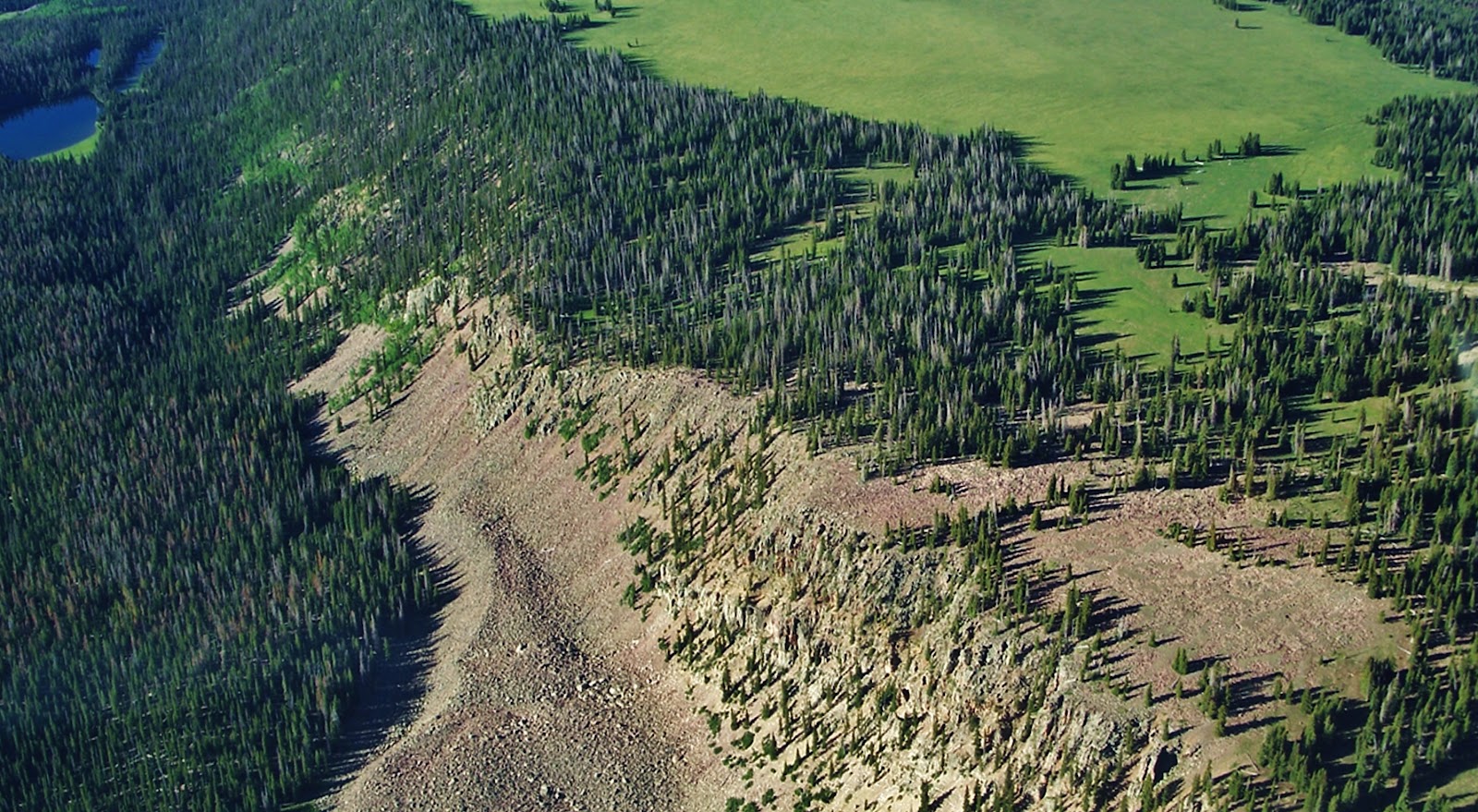
Here we are moving to the west seeing above to the right Jackson Park. Right in the center of this photograph is the escarpment I got to last year which kept me from going down into the basin. Along this same escarpment to the left, or south, you get to areas of pines and aspens where perhaps one could get down into the canyon although very steep and rocky.

From up the ridge we look south towards beautiful Jackson Park.

We are moving towards the west looking southeast and if you look closely to the right of the pines that divide the right quarter, you can see a fine line that is the trail coming out of the pines where is found the only sign in the area I insert below. (NOTE: If you can't see said trail, click on the image to enlarge.) That trail continues up into the Swift Creek drainage, then forks, the trail going north west climbs 11,613 ft. Bluebell Pass, the right fork takes you to the Timothy and Carrol Lakes a distance of 13 miles.

This sign is next to the only spring in the area. Last year I camped near here.

Now we have moved around to the southwestern edge of the Park. In the middle is where I found the only water in the area that comes from a spring at the edge of the second grouping of pines.

We're looking at Jackson Park from the south with Crow Canyon on the right. Possibly a good pathway down into the canyon is from the far southern point of the park in the lower middle of this photograph, and from there swing up the canyon to the basin.

I will likely first attempt getting down into the canyon from this southern part of Jackson Park.

Another of my priority trips is to Crater Lake a truly exotic area I've never seen a picture of in any of the guide books. You can come up Lake Fork from Moon Lake on the South Slope, a gradual elevation gain hike of around 20 miles.

A shorter, but a much more adventurous and spectacular route of 16 miles is from the East Fork of Blacks Fork Trailhead on the North Slope. In the upper reaches you climb 12,165 foot high East Fork Pass (my name) with 13,219 foot high Mt. Lovenia dominating the scene.

Here I am coming from Mt. Lovenia, with the trail (and pass) to the left.

My buddy, Ted Packard is looking from East Fork Pass towards Red Knob. You can see faintly the trail along the slopes of Red Knob winding its way towards the pass along the spine of the High Uinta Mountains. You actually go down 465 ft. in elevation to get to Red Knob Pass.

We are now on 11,700 ft. Red Knob Pass looking towards the Dead Horse area at the head of the West Fork of Blacks Fork on the North Slope. We will follow the Higfhline Trail to the left down into the South Slope's Lake Fork Drainage.

Now on the South Slope in the Upper Lake Fork Drainage's arctic tundra we see our objective in the middle of the photograph--Explorer Peak in the dead center at whose base in a glacial cirque is Crater Lake. Once switch-backing down from Red Knob Pass you go off-trail but as you can see it's easy hiking.

Here we are at one of the jewels of the Uintas--its deepest lake at 147 feet. For years I have yearned to get up on the ridge to the north, or right, and bivouac there to attempt getting a spectacular wide angle photograph of the lake and Explorer Peak. This trip will likely be the last of the summer, and depending on how I'm doing, I might just go from here east towards Porcupine Lake and Pass, even climbing the pass to test the unnamed lakes above North Star Lake in the Garfield Basin, then backtrack to Squaw pass and the alpine lakes of Little East Fork of Blacks Fork, where Bigfoot has been reported seen more than in any other area. From there back to the Trailhead. That could be more than I can chew, but we'll see......stay tuned.

The 3rd backpack will be to the off-trail Reconnaissance Lake and Triangle Mt. area at the head of the Rock Creek Drainage. Access is from the Highline Trailhead on the Mirror Lake Scenic Byway. The hike leads you up over Rocky Sea Pass and east to the Rock Creek Drainage. I will follow the above timberline trail that circles the far reaches testing the waters of several remote lakes and on to Reconnaissance Lake--about 20 miles from the Trailhead.

For me this beautiful alpine scene rivals Red Castle as the most beautiful mountain scene in Utah.

Triangle Mountain is 12,385 feet high, with the lake above timberline at around 11,150 feet elevation.


I have been to this area 3 times, but love it so much that I hope to be able to make it one more time before considering hanging up my backpack.

While in this wonderful area I will attempt a few extras, like, climbing the saddle to the east to get photographs far below of Allsop Lake and the East Fork of the Bear River on the North Slope--such as was done by my friend Doug Perry and his boys a few years ago. From here I will also get back on the trail and follow it east to Ledge Lake and continue towards Dead Horse Pass, detouring off trail briefly to get improved photographs of Continent Lake (you can see what I've got on my "1000 Mile Whirlwind Backpack in the High Uintas ")

The 4th area we will enjoy seeing here, but which will actually be my first backpack of the season, is to little visited and mysterious North Slope's Middle Fork of Blacks Fork, part of my purpose being the pursuit of greater understanding of the "unsung American heroes" the TIE HACKERS, without which the West wouldn't have been won. Pretty bold statement, right?

For those who don't know what the heck I'm talking about, permit me to give a very brief explanation. Above we see a tie hack cabin moved piece by piece from the Steele Creek area and put back together at the Mt. View Ranger Station to the north in Wyoming.
In 1867 the Transcontinental Railroad was being constructed to the north of the Uintas in Wyoming and millions of railroad ties were needed.

Rugged Irish immigrant lumbermen were sent into the Uinta's North Slope, and other areas to work 12 months a year making railroad ties with their broadaxes.

Much of their work was done in the winter time when they could more easily transport the ties using sleds.

They were accumulated in the river and creek beds behind what they called "splash dams." When the thaw came and the lakes behind these temporary dams filled up the dams were blown with dynamite and the ties were washed or "splashed" downstream into Wyoming where they were picked up by the railroad.
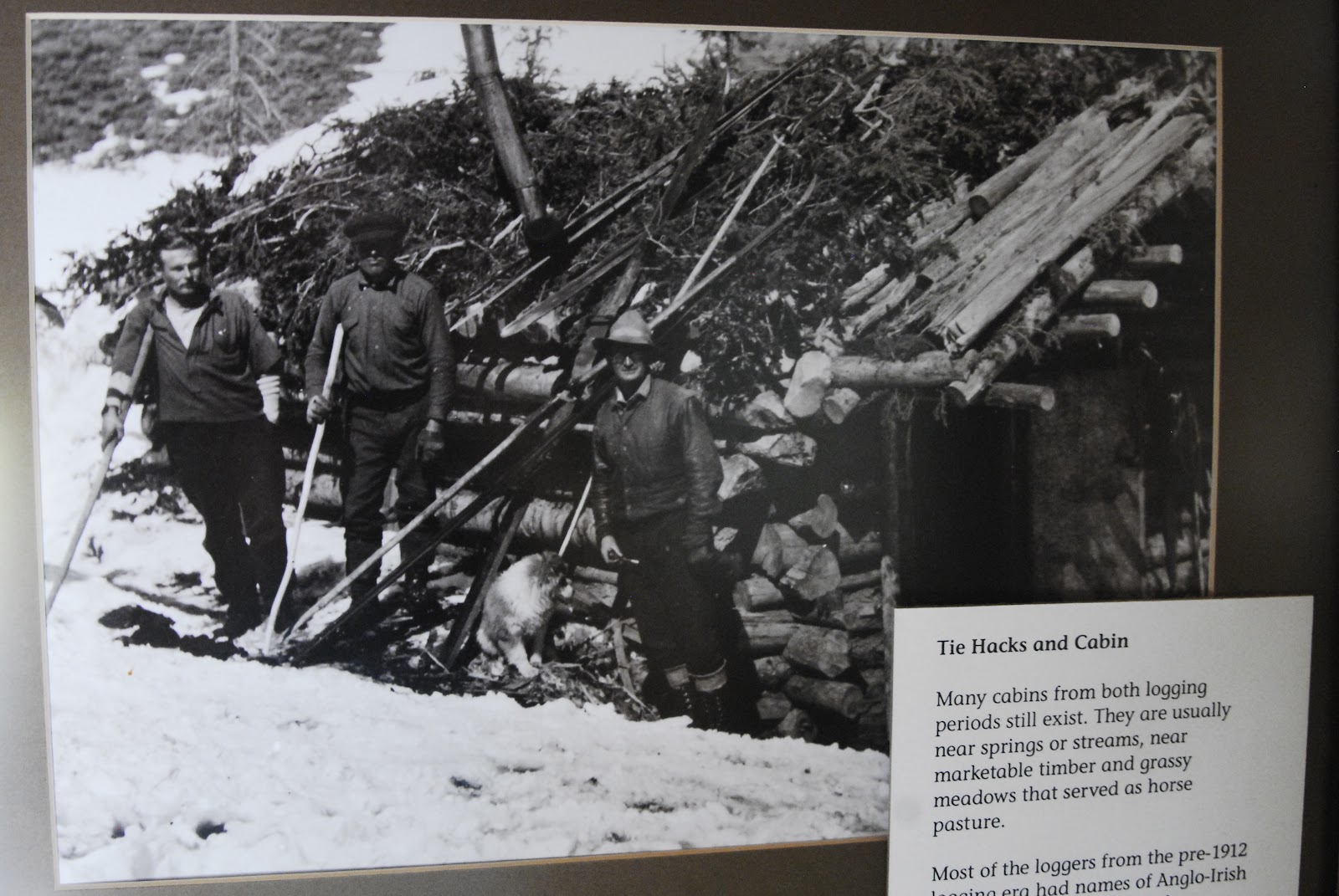
These tough tie hackers built their cabins, and small communities in the lodgepole areas of the Uinta's North Slope.

The area where I have found and photographed the most ruins is an area that is never mentioned in any of the books, scientific studies, and Forest Service reports. It is the little visited beautiful Middle Fork of Black's Fork that leads to 13,165 ft. Tokewanna Peak. This will be my 3rd trip into the area. This trip, among other purposes, is to begin getting my mountain legs and lungs in shape--acclimatizing myself for higher and more difficult elevations.

For the first couple of days I will be at elevations between 9,000 and 10,000 feet crisscrossing back and forth across the canyon mapping and photographing all the sites, and dating all of them--either from the early 1867-1880 period, or the 1912-1935 period.

I'm just showing 2 sites here of the dozen or so I have found and photographed. The one above was quite large and possibly a dinning hall, also used by the tie hackers for dances and social gatherings.

That task accomplished, and hopefully acclimatized, as in recent years I have experienced some High Altitude Sickness, I will then move up the canyon towards Tokewanna Peak and Bob's Lake.

Bob's Lake is on the right side of the ridge coming off the peak. Three smaller lakes are found in the drainage to the left of the ridge.

Bob's Lake will be my first objective in the high country. Three years ago I caught very strong Tiger Trout, and I would hope that they are still alive and much larger. From Bob's Lake I will climb the ridge to the east, or left, and drop over into another branch of the canyon.

In this area there are three small lakes, two of which possibly have fish and I will test them and report.


Unless you are a young buck that has kept yourself in good shape with a lot of physical activity, you'd better be willing to work real hard at getting in shape. Hiking with a load on your back above 10,000 feet is no cake walk--in fact the stress is multiplied several times over normal hiking. If you are in your 77th year, such as will be the case with me, you have to do much, much more.
For three years I have persisted in having a job that is the perfect job for me to have a chance at being in shape. Some have called my job "the lowest in the food chain" but I have found that going on an hour walk three times a week has me going downhill. I need much more, and in my job as a "shopping card herder" I do around 7 miles 4 times a week, half of it pushing long chains of carts, jumping at the chance of doing all the heavy lifting possible with customers, and I'm known for jogging a lot to help a customer with purchases, or go get a stray cart.
For three years I have persisted in having a job that is the perfect job for me to have a chance at being in shape. Some have called my job "the lowest in the food chain" but I have found that going on an hour walk three times a week has me going downhill. I need much more, and in my job as a "shopping card herder" I do around 7 miles 4 times a week, half of it pushing long chains of carts, jumping at the chance of doing all the heavy lifting possible with customers, and I'm known for jogging a lot to help a customer with purchases, or go get a stray cart.

Of course that's only a part of the need. The rest I do at home putting a pack on my back and getting hours in while watching Utah Jazz games, and other things on TV. Right now, in April I'm doing it with a 50 lb. pack. That will increase up to 65 pounds as the backpacking season approaches. I also do 40 to 60 push ups during time-outs as seen in the YouTube video.

Some of you might remember what happened last season. I took 2-1/2 months off from my work to have one heck of a backpack summer.

My first trip was a bust as everything was still snowed in. I drove around, took photographs, checked with the Forest Service, and did YouTube videos reporting conditions, but didn't get any exercise.

The 2nd and 3rd trips and weeks were pretty much the same. Trailheads snowed in, roads washed out, and bridges down. The high country was inaccessible like I had never seen before. The forest Service recommended waiting until August.

I finally was able to get to a Trailhead and go backpacking, but found that a month of inactivity had really hurt me. When you're older you lose your conditioning much faster, and have a much harder time getting it back. Being out of shape produced a domino effect--not just phsical weakness, but also my weakened condition had High Altitude Sickness slow me down.

Having a tough time, I weakened in more ways than one, and dreamed of Forest Gump running around the country for 3 years, having accumulated a following, when he all of a sudden stopped turned around and was about to speak. Someone yelled out, "Quiet he's going to say something!" He did, saying,

I came to that conclusion too, thinking "I'm finished!"
That was after my survival experiences on the trail to Garfield Basin, and again at Jackson Park frin where I headed down the trail with a terrific thunder storm bearing down on me all the way. I moved pretty good and did the 6 miles in record time. Pretty soon, reflecting on how well I did and felt, I recalled how I've preached, "NEVER GIVE IN!"


So I concluded I was far from finished. I just had to keep working, working out, and next summer work right up to the day before I put on my pack for my first backpack.

Then I will be wise with that first trip and gradually get used to the extreme stress of high altitude hiking with weight on my back and keep pecking away at my scheduled trips, one by one and do the best I can, but with a foundation of hard work, and feeding my body properly as will be outlined in Part 2.

So tune in to Part 2 that will be coming in a week or so.

your a stud, much respect.
ReplyDelete