Click below for previous post:
Backpack #2--UINTA RIVER...ATWOOD TRAIL....NEAR CHAIN LAKES & TOUGH ROBERT'S PASS... H.A.S. & HEART PROBLEM... Almost another "Forest Gump moment".... No "GIVING IN YET!"


NOTE: None of the photographs can be used without written permission from Cordell Andersen.
EMAIL: cordellandersen@hotmail.com
UPDATE Monday AUGUST 18, 2015

I'm presently into the 4th day (of 4) doing research in the Uintah Basin starting last Saturday spending a couple of hours at the Saloon at DEFA'S DUDE RANCH on the North Fork of the Duchesne River, and, in addition to a few new High Uinta Friends, came away with a treasure load of great information, history, legends and "tall tales" from my new buddies. One of them, Micky, the baretender says hello below:

Then I was on to the Forest Service in Duchesne and the Public Library, and will finish up at the new Duchesne County History Center.
I hope to make it to the Henry's Fork Trailhead by Tuesday evening, probably late...and......Wednesday morning be on the trail towards Gunsight Pass taking me to the Kings Peak area, and on to set up an above timberline camp in the shadow of 13,387 ft. Mt. Jedediah on tiny U-75 lake which produces monster brookies.

I have programmed my SPOT Tracker, that being the link if you want to follow me on the trail & see where I am each evening on Google Earth. I now have a more reliable sat phone from Russ Smith & SKYCALL SATELLITE (where you can rent your's too) and hope to be able to make my report early Saturday to KSL OUTDOORS RADIO and, if all goes as planned, make a day hike that day from my camp on U-75 lake up to "Little Andy Lake" and be the first to report on this alpine lake that is at 12,203 feet, a hop, skip and a leap from South Kings Peak.
Then on to Beard Lake where I once had on briefly what would have been a Utah State record brookie (and winner that year of the FIELD & STREAM fishing contest), & Trail Rider Pass, and then test the waters of all of the lakes in the George Beard Basin and be the first to post a report world-wide on that basin..... and we'll see what else.

I know that lately I've been just "so much hot air" but have to practice what I preach...NOT GIVING IN...EASILY, and doing my best in my 80th year to avoid having a "Forest Gump moment!"
EMAIL: cordellandersen@hotmail.com
NOW THE PHOTO/ESSAY
A --"DEADLY AMBUSH" --NEAR GUNSIGHT PASS
August 19, 2015 at HENRY'S FORK TRAILHEAD
The Trailhead is 30 miles south of Mt. View, Wyoming, or 68 miles from Evanston.

The Trailhead parking lot was overflowing with cars. There would be a literal parade of mostly King's Peak climbers coming and going. If you're new, KINGS PEAK is Utah's highest mountain at 13,528 feet. With so many people on the trail I wouldn't be able to stop and talk to everyone like I usually do.
I had come the afternoon and evening before all the way from the Uintah Basin, slept in some and got a late start around noon.

In my 80th year, I had done my best to get my load weight down for an 8 day backpack to 34 lbs. For such an important trip I desperately wanted to take my good Nikon camera, rather than the Pentax point-and-shoot used on the Uinta River trip. So I focused on losing 5 lbs. of body weight during the preceding week and made that goal.....
So, you'll notice I don't have wrapped around my midsection the "spare tire"...at least it's smaller, nor my new photographic waist pack (that with my Nikon camera and extra lenses weighed around 10 lbs.--12 lbs. with tripod). Rather I only had a lightweight waist pack with the camera, a fish-eye lens, and a much smaller radio--a Grundig seen below, weighing only a few ounces....all in all saving around 7 lbs. of weight from the normal pro-photo equipment, but that small waist-pack brought my load weight to 40 lbs. including water.....but compensated for by 5 lbs. less of body weight.
 NOTE: The new radio for this year, shown previously, turned out to be a heavy (l lb.) piece of junk!
OH.....ALMOST FORGOT TO MENTION....
As usual I had from Russ Smith at SKYCALL SATELLITE a satellite phone....this time one a bit more reliable although a bit heavier, like you see below:

As well as always having my
SPOT PERSONAL SATELLITE TRACKER
to be used daily.


OH.....ALMOST FORGOT TO MENTION....
As usual I had from Russ Smith at SKYCALL SATELLITE a satellite phone....this time one a bit more reliable although a bit heavier, like you see below:

As well as always having my
SPOT PERSONAL SATELLITE TRACKER
to be used daily.


Elevation at the Trailhead was a bit over 9,000 ft.--a signifcant advantage over the Uinta River Trailhead that is around 7,000 ft.

Map #1 shows basically the territory I'd cover the first day...from the trailhead around 4 miles with 1,000 ft. of elevation gain. Good 1st day for an old guy in his 80th year.

A very short distance from the Trailhead you cross the Wilderness boundary and right off begin seeing backpackers coming and going.


We are in historic country.....
.....paralleling the Henry's Fork of the Green River. This well known land-mark river was named after he who most of his life was known as "Major Andrew Henry," but who had actually ascended to be a brigadier general in the military, and then was elected lieutenant governor of Missouri. Later he became the partner of General William H. Ashley and their fur-trading venture on the upper Missouri River and together would go on to revolutionize the Western fur trade with the help of all the famous mountain-men such as Jim Bridger, Jedediah Smith, and others mentioned below.
.....paralleling the Henry's Fork of the Green River. This well known land-mark river was named after he who most of his life was known as "Major Andrew Henry," but who had actually ascended to be a brigadier general in the military, and then was elected lieutenant governor of Missouri. Later he became the partner of General William H. Ashley and their fur-trading venture on the upper Missouri River and together would go on to revolutionize the Western fur trade with the help of all the famous mountain-men such as Jim Bridger, Jedediah Smith, and others mentioned below.

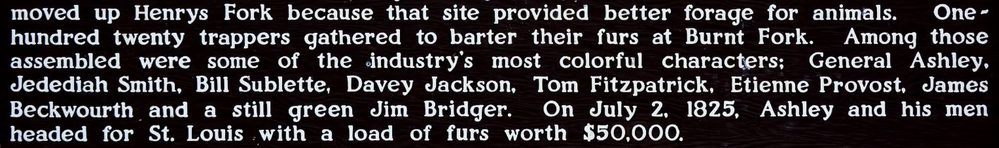
As we can read in this Historic marker just over the line into Wyoming, it was on the Henry's Fork where the very first ROCKY MOUNTAIN RENDEZVOUS was held in 1825.

On one of my explorations I made it a point to try and pin-point the exact spot where this famous Rendezvous was held....seen below


So, here we go up the famous Henry's Fork of the Green River. Once again, as many of the streams coming out of the High Uintas, very seldom if ever fished....and it would be good....it will be good as the "streams of the Uinta" will be my next focus, once I get the "unique book" put together I'm now working on.

In good style I made it to my first camping spot 1.5 miles below Elkhorn Crossing (about where the red-dotted trail leaves the map above), went for water, and while my Gravity Works system did its magic purifying my water.....

...I set up camp, and soon was snuggled in for the first night....but....at about 10:00 my air mattress went flat!

...I set up camp, and soon was snuggled in for the first night....but....at about 10:00 my air mattress went flat!

Comfort and being able to sleep would be a problem, but the main one would be no insulation between me and the cold ground...especially with my quilt that is designed to cover and keep one warm on the top side, but for bottom warmth dependent on the air mattress. Luckily it had been sort of cold at the trailhead and so, fearing colder weather in the high country, I had thrown in my long-johns...which I quickly put on under my pants and so was a little protected.

However, by 1:30 I just couldn't sleep and so got up to see if I couldn't find the leak and fix it....which you'll notice above was fixed, not with the Therm-a-Rest repair kit as patches were gone, but using tent repair material and my trusty Plastic Surgery glue, that has served to repair water bladder, glasses, gluing on a crown that came lose, fixing head lamp, and now the mattress.
I won't go on a trip without said glue, that is much better than normal Super Bonder.

Up the trail the next morning I said hello to a Peruvian sheepherder, but didn't have my camera at ready until he was up the trail. Over the years I've met herders from Mexico, Chili and now Peru.

Soon I arrived at Elkhorn Crossing where the North Slope Highline Trail crosses the Henry's Fork trail.

The right hand fork goes towards Bear Lake, then forks with the North Slope Highline Trail continuing west, the other fork goes up the west side of the Henry's Fork Basin. There's actually an un-marked trail that goes up the middle---the right side of the stream, which I have followed to go to Henry's Fork Lake, and on to Castle, Blanchard, and the most remote, Cliff Lake. My trail for this trip continues south, crosses the stream and then forks again.

Here we get our first glimpse of the high country enshrouded in smoke from the forest fires all over the West.

On the east side of the bridge the trail forks, mine going up towards the south and Dollar Lake and on to Gunsight Pass, the Uinta River Drainage, and the Kings Peak area. This trail follows one of the two ancient trails over the Uintas used for centuries by the Native Americans.

The other fork going east is the North Slope Highline Trail that first leads to the Beaver Creek Drainage and its West Fork that takes one to the base of Gilbert Peak, Utah's 3rd highest at 13,442 ft.

As I was getting up into the high country I got to speak Spanish with three other Peruvian sheepherders.


In another mile or so there loomed through the smoke to the west CASTLE PEAK at whose southern base lies one of the remote and mysterious lakes of the drainage, Castle Lake you see below.

It is described in one guide book as not only remote and little visited, but "mysterious." That got the best of me a few years ago and I had to get there. I made the entire 12 miles to it from the Trailhead in just one hard 1st day--wish I could still do that! But, no mystery, just tons of sassy eastern brook trout!

Soon there comes into view our first glimpses of Kings Peak...the triangle shaped peak on the right half of the panorama....we zoom in on below.


Then passed me Trent and Sally Johnson, on their way to camp at nearby Dollar Lake. I needed some rest so let them get up ahead of me where they rested below with their objective hanging over their heads--KINGS PEAK.


Then their companions came by: Conner Sugrue and Sarah Ann Skousen.

I finally caught up with them and we had a BYU reunion....me from way back when BYU was more like a high school! We were at what on the topographical map below is the 7.45 mile point, actually more accurately 8.5 miles from the Trailhead--I say that, as to the route distances on the topo maps, you should add 15%. This is the Dollar Lake area where many camp, and then take a day hike of 8 miles to Kings Peak, for a 16 mile round trip hike.

I felt like I had to go on a bit further towards Gunsight Pass to make my 3rd day shorter. I would be above the 11,000 timberline and went on to about 11,400 feet that would have been above the line of pines we see below.

This is an old photo of the area as I was moving up towards the pass and the proposed camp site...we see on the map below.

Below we get a view towards Gunsight Pass from the stream that gushes out of Blanchard Lake, and the arrow pointing to approximately the area where I had planned on camping....and actually got to it at about 11,400 ft. in elevation.

The camp site was to be in a little clump of alpine firs like we see below, with water nearby. I actually didn't take pictures as I was beginning to feel so bad that photographs were the last thing on my mind.

It was a spot where I had camped twice before on climbs to Kings Peak.
The first time was in late August 2004, 6 weeks after knee surgery, when I hadn't exercised for most of that time, and it wore me out to do it all in one day from the Trailhead. Extra takes of Glutamine and Calcium/Magnesium had me come out of it. The next day I went on to camp on Kings Peak and it developed into one of the great SURVIVAL EXPERIENCES of my life complicated on my way out with a heart attack....8 miles from the Trailhead in the midst of which my desperate prayer was miraculously answered. Click on that if interested.

Normally this is the way I feel and look in the mountains, but this time at the proposed camp site at about 11,400 feet all systems were falling apart and I all of a sudden began feeling very sick......
............what was happening?
............what was happening?
I was extremely fatigued and unsteady on my feet. Wheezy breathing had been developing for the last hour. I had the feeling I was coming down with the flu feeling body temperature possibly rising, a splitting headache, and nausea with the very thought of food had me wanting to vomit.
Worst and most worrisome was that my pulse was very fast, and I was able to detect a very erratic and irregular heart beat which I hadn't had for at least 6 years, except for a couple of weeks ago one night on the Atwood Trail.....which then had me worried and deciding to drop down in elevation returning to the trailhead--rather than trying to climb tough Robert's Pass.
AMBUSHED BY "HIGH ALTITUDE SICKNESS" or "ACUTE MOUNTAIN SICKNESS - AMS"
My body was basically being deprived of oxygen and without that all bodily systems begin to break down and can eventually fail if something isn't done quickly.
Normally most people's bodies adjust, adapt and quickly acclimatize, but sometimes, due to being out of shape, or sick with a depressed immune system, or weakened with advanced age, etc. normal bodily functions fail, and the spiral downward of High Altitude Sickness can set in which is what was happening to me, converting me into something I wasn't....very tired like we see below, but I couldn't afford to think about sleeping........but had to act quickly!

It was something to be concerned about, and the heart irregularities were the clincher. To make that more dangerous I had somehow lost the tiny EMERGENCY KIT I have carried with me ALWAYS since I experienced a heart attack near here in 2004. It is a little bottle of Nitroglycerin tablets, also with a couple of Aspirin, and blood pressure medication....like you see below crossed out as I HAD LOST IT!

I did have Aspirin and immediately popped one in my mouth and chewed it up, then the "Miracle Recovery Formula:" 1. A recovery drink with 5 gms of Glutamine, mixed with Electrolite Replacer, and Calcium/Magnesium. 2. 6 capsules of WELLNESS FORMULA, and 3. one tablet of DEFENSE PLUS. I then shouldered my backpack, said a word or two of prayer....and
HEADED DOWN!
....which is the only effective solution
 A week later I finally found my little Emergency tin....in my running shorts!

A MATTER of LIFE and DEATH!
It's worth pausing just for a moment or two to understand this better. First with some basic guidelines:

NOW A FEW INSERTS FROM THE EXPERTS FOR GREATER UNDERSTANDING


PREVENTIVE SUGGESTIONS
- For people who do not know the rate at which their bodies
- adjust to high altitude, the following preventive measures are recommended.
- 1. acetazolamide (Diamox) a prescription medication can help speed acclimitization and thereby prevent AMS.
- 2. Avoid physical exertion for the first 24 hours.
- 3, Drink plenty of fluids, and avoid alcoholic beverages.
- 4. Consume a high-carbohydrate diet.
- 5. If mountain climbing or hiking, ascend gradually once past 8,000 feet (2,400 meters) above sea level
- 6. Increase the sleeping altitude by no more than 1,000 feet (300 meters) per 24 hours. The mountaineer's rule is "climb high, sleep low." This means that on layover days, a climber can ascend to a higher elevation during the day and return to a lower sleeping elevation at night. This helps to hasten acclimatization.
- Google it and inform yourself.
DON'T FOOL YOURSELF
For most of my life there has been no problem. For my first year on the High Uintas Wilderness Project, including my "27 Day Expedition," there was never a hint of this. Then I got older, had cancer and knee surgery and didn't exercise for a month or so and went right up to camp at over 12,000 ft.....and WHAM!
Another time it hit me after having got sick and needing my emergency anti-biotic and when recovering, but still weak, worked to get back to civilization climbing a 12,300 foot pass....and WHAM!
Over the next few years I went through other surgeries on ankle, knee, back and eventually on my hip while getting older and apparently more susceptible requiring greater awareness and ability to act quickly.
THE BEST BACKPACKER....INVINCIBLE?
The best backpacker I have ever known, who is my age, until two years ago never had a hint of this problem. Then on a backpack up Swift Creek, over Bluebell Pass, then down to Yellowstone Creek, and from there up the canyon and over Tungsten Pass to the Garfield Basin, and there at about 11,000 ft. all of a sudden he had High Altitude Sickness and actually lost consciousness. His poor brothers didn't quite know what to do, and...wouldn't you know it, they were experts and hadn't felt the need of following my advice to have a SPOT tracker, and/or satellite phone!
They finally revived him, took all of his load, and carefully headed DOWN into Yellowstone Canyon. At 9,500 ft. he was a new man, shouldered his pack and was the first down the trail, but he came close to his demise!
I will tell all the details of this and other similar stories in the book I will be putting together during the next 12-18 months.
SO....WHAT WAS I TO DO?
I had pop into my mind the melodious voice of.....

.....singing:

So, I "folded em" and "walked away" going DOWN, the only effective solution, heading carefully for the Dollar Lake area where I jumped a bull moose and actually hit my SPOT Tracker OK button intending to camp there.....

.....but then thought it best to use the last hour of twilight to get down another 700 feet of elevation and camp at Elkhorn Crossing's 10,300 feet elevation.

By the time I got there enough light was left to go to the stream for water and get it purifying, then with my headlamp I set up my tent and was soon snuggled in for the night grateful for having had the wisdom to recognize what was happening to me and what I had to do quickly. Yes, and thankful for having had the strength to move down the trail, and gradually feel better and pick up the pace, lengthen my stride, and make it to the safety of a lower elevation. I actually had hiked about 9 miles that day.


....but that didn't happen...yet, so up and raring to go the next morning, assuming that going downhill I'd be at the Trailhead in short order!
ON THE TRAIL....AGAIN
Wow! Did I sleep good.....not even waking up until 9:00 AM. That little wrestle I had with life really wore me out and so I was slow to move down the trail....but I did move a little at a time, passing by, but mostly being passed by all kinds of outdoor lovers. I had 5.5 miles to go to the Trailhead, and the safety and luxury of my tiny travel trailer "CABIN A"
LITTLE DID I KNOW THE "BLESSING IN DISGUISE" AHEAD OF ME FOR HAVING "Folded em" AND COME DOWN THE TRAIL.....read on to see what I mean....
Among the many seen on the trail was a group of youthful Forest Service workers going up the trail.....

...and soon behind them came a Wilderness Ranger on horseback. She looked at me and shrieked,
"NO! YOU'RE DEAD!"

She was Teresa Facinelli who I had met 8 years ago, along with her husband Bob, at the Hewinta Guard Station on the West Fork of Smith's Fork,


They had introduced me to the "TIE HACKER WORLD," beginning for me a wonderful journey opening up the mysteries of all the ruins on the North Slope, incredibly enhancing my High Uintas experience, and putting me around #1 on Google searches with 14 photo/essays and YouTube videos on the important subject.

She told me that a few years ago she had Googled my name and found the following obituary announcing that I had died in 2010.

I had in the past also seen the obituary and had a good laugh. This was MUCH MORE THAN AN NDE ("Near Death Experience"). I APPARENTLY HAD BEEN REINCARNATED INTO A NEW LIFE!

But, still very much alive, we had a great reunion and conversation and then we moved on.
A BLESSING IN DISGUISE....if I hadn't of had trouble and backed off...I would have never ran into Teresa, nor met all these other great new friends!

A bit further down the trail I came upon another group of backpackers....this time the couple in middle from Utah State in Logan. Both of my parents were from there and had studied at Utah State.
I admitted liking it a lot--except when playing BYU!
I admitted liking it a lot--except when playing BYU!

Note: Please excuse the poor photo, but it was the only one I got. Scott will send me a good one soon to replace this poor one.
Last of all I met SCOTT NELSON and his two handsome boys, Scott Jr. and Adam. They were returning from having scaled King's Peak. In sharing some my experience, Scott admitted that as they climbed from Anderson's Pass to the summit, he began experiencing also the symptoms of High Altitude Sickness, or Acute Mountain Sickness (AMS), and was grateful to learn about it. We both agreed that:
It is something all should be aware of and that such understanding could literally save lives.


It is something all should be aware of and that such understanding could literally save lives.
My weekly report on Saturday morning, August 22nd, was phoned in this time with my cell phone from my weekend "rest camp" in the Walmart parking lot in Evanston, Wyoming. If interested you can listen to the podcast for the 1st hour, at about 6:15-20 AM

AT THE END OF THE BACKPACK....
....well, I finally made it to the comfort and luxury of my earthly mansion, and was back with my faithful buddy, "Wilson." I was grateful ....for the success of the trip--running into Teresa, and acquiring wonderful new friends, and having backpacked about 20 miles in the 3 days, even though not reaching my goal .....

First I made the mistake of thinking that one of you young bucks out there would have to get to "Little Andy Lake," photograph it and get the report to me....BIG MISTAKE! UPDATE: Hold off....I'M GOING TO DO IT IN 2016 WHEN I'M 80 YEARS OLD! Read on to see how.
So, for all of you, my HIGH UINTA FRIENDS, where does this leave me?
Note: Below are my High Uinta Friends from 2013 who represent the many hundreds from 2003 to the present......One of these days I'll add to this montage pictures of all the High Uinta Friends I have been blessed with since 2003--that will be an incredible conglomeration of magnificent friends!

This great group of friends is more and more evolving to be my "CHEERS" sort of "brotherhood," "where everybody knows your name, and they're always glad you came," or..... glad I came out with a new photo/essay or YouTube video!
Did I have another FOREST GUMP MOMENT?

Not really, it was just another "glitch" on the trail ....
..as many others I have had, and an opportunity for a TEACHING MOMENT...about High Altitude Sickness for the blessing and benefit of all those who stumble across my website and pay attention. If you do I guarantee that
LIVES WILL BE SAVED--MAYBE YOURS or THAT OF A LOVED ONE!
For the rest of this season I will focus more on the research and writing aspects of the Project, and for the future accept that the time is fading for "heavy duty backpacks,"--
EXCEPT FOR ONE MORE IN 2016!..
....normal backpacking will continue--as it has so far held at bay the "peripheral neuropathy" that was trying to cripple me....and of course also "old age," so...
... you'll have to wait a while longer for me "to grow old!"

No comments:
Post a Comment