This is a photo/essay of a 2009 road trip seeking tie hacker sites accessible by car. I just noticed (July 31, 2012) that the program was somehow lost. I am restoring the photographs and will from memory write quickly new captions and explanations. When I have a little more time on my hands I will go back to my research and describe more fascinating details of the places visited during this trip of discovery.
THE TIE HACKERS OF THE HIGH UINTAS NORTH SLOPE
The tie hackers were Irish lumbermen immigrants sent in 1867 into the Uintas to work 12 months a year making millions of railroad ties with their broad axes for the Transcontinental Railroad being constructed north of the Uintas in Wyoming.

We begin the search in Mt. View, Wyoming, one of the "Gateways to the High Uintas," at a tie hacker cabin located at the Ranger Station. This cabin was carefully taken apart at Steel Creek on the Uinta's North Slope and put back together here.

We begin the search at the Ranger Station.


We see in the cabin one of their broad axes with which they made millions of railroad ties.

At the Ranger Station I was able to photo copy the only reports available on the tie hackers which are all from the modern tie hack period--1912 to about 1940. The early period from 1867 to around 1880 was prior to the organization of the Forest Service, and almost no original, first-hand information is available.

I insert here the title pages of several of the reports.


From the Ranger Station in Mt. View I backtracked to Fort Bridger State Park to see if I could find any information about the tie hackers.


I found no references to the tie hackers, but nonetheless was fascinated by what I learned about the early history of the area. From there I returned to Mt. View and visited the Public Library.

The visit was very fruitbul jotting down references to one book on the tie hackers, noted below, which I thereafter acquired.
.jpg)
Also I found a reference to a DVD which also was subsequently purchased.

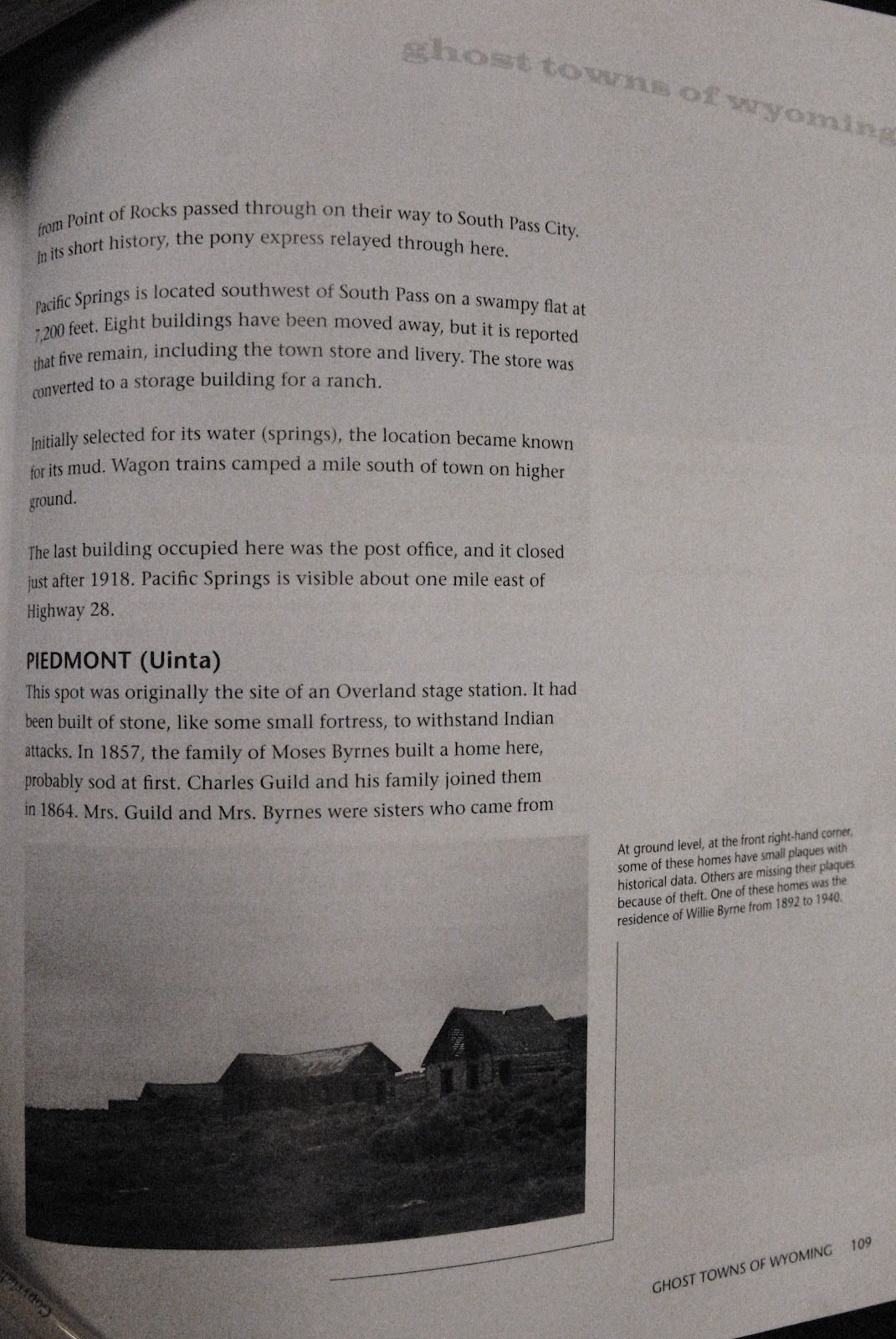
The personnel were most helpful and we found several other references related to the tie hackers, the first being the ghost town of PIEDMONT, located west of Mt. View.

Of great interest I also learned of one of the early towns the tie hackers and railroad men had established near the Bear River about 30 miles north of the Utah border. It was called Bear Town, and described as "one of the liveliest, if not the most wicked town in America." It only lasted 2 years and then quickly disappeared like Sodom and Gomorrah after occurred there the "bloodiest battle between whites in the history of Wyoming!"
It was easy to continue my search heading west looking for Piedmont and Bear Town.

Soon I was on a gravel road seeing a wind farm to the north, then left the green ranch lands winding my way through sagebrush country and in another few miles came over a rise to view in the distance the Piedmont area.


Soon the charcoal kilns of Piedmont and ruins of the ghost town appeared.


The ghost town lies on private land with No Trespassing signs posted, except at the kilns that can be visited. The town is tied to the tie hackers as they provided the wood burned in the kilns to produce charcoal.

Eventually coal mining made charcoal obsolete. The community had a boarding house, saloon, general store and post office and was used by soldiers from Ft. Bridger for their time off and weekends.

Moses Byrne established the community that originally was an Overland Stage Station. Many of the residents were from Moses extended family.


This was most likely the school house.


From the road you look acrossed the stream at the Cemetery that is accessible to the public. I photographed all the tombstones, and will insert here a few. The birth and death dates often are very telling of the difficulty of pioneer life.

Here we are looking back at the road.


This isn't it, but the last person buried in the cemetery was in 1998 and signs of flowers placed on graves were present. One of these years I will spend my Memorial Day there and see who I can meet and what I can learn about the community.

I wanted to find Bear Town, but didn't have enough information, nor time. Later you will notice I did find the site and found some artefacts, and by that time learned much more about the fascinating story of this fabled place.

So I turned south and headed for the Uintas seeing along the way a few antelope, and treaded ground where many years ago were found herds of American Bison. Bones of these unique mammals have been found in North Slope canyons.

We drive south from Mt. View crossing Wyoming ranch lands and the band of sagebrush country that surrounds the High Uintas.

Right on the Wyoming-Utah border we find a secluded little spot called "Suicide Park." This represents one of the sadly darker sides of the tie hack culture. The tie hacks worked a very hard and sometimes solitary life and often didn't have many family ties.

When they grew older they often began having a very difficult, if not impossible, time carving out enough railroad ties to support themselves. At Suicide Park three tie hacks are buried who just couldn't take it any longer and took their own lives.

A Forest Service placard tells briefly their story. They are all from the modern period of the Tie Hack Culture--1912-1940.

Eventually when I finish my research and exploration and put this whole story together I will tell in more detail the story of these three.

For now I'll only show one of the stone markers. You will notice the name is not Irish. The tie hackers from the 20th century, rather than being Irish as in the early period, were rather Scandinavian, mostly Swedish.
I might add, now in 2012 when I'm doing my best to put together again this 2009 story, Suicide Park has deteriorated greatly and needs to be rebuilt.
I might add, now in 2012 when I'm doing my best to put together again this 2009 story, Suicide Park has deteriorated greatly and needs to be rebuilt.

We now have driven a few miles north to the North Slope Road and are heading east towards the Hewinta Guard Station road (not marked, but is the first that goes south once you pass Steel Creek). I show the Hewinta Guard Station in the First tie hack photo/essay where I met Teresa and Bob and began learning about the fascinating tie hack culture.

Steel Creek is found between the East Fork of Blacks Fork and the West Fork of Smith's Fork. Up this creek is found the ruins of the Steel Creek Commissary--a tie hack site from the modern period. To get to it you take the Hewinta Guard Station road and shortly veer to the right on usually a muddy road that takes you soon to the site.


Here we see debris, such as the old shot up stove seen to the right, that shows this is a site from the 1912-1940 period.

Here we see what for me has been a rarity at tie hack sites, an outhouse turned on its side. Below I'll zoom in.

Zoomed in we see the seat and hole of the outhouse.

This is the filled up outhouse hole.

Here we see the crude lid for the hole.

We now leave the Steel Creek Commisary ghost and head west on the North Slope Road.
NOTE: Up the road from the Hewinta Guard Station, just a mile or so from here, you come to the West Fork of Smiths Fork Trailhead. Up that trail (and old road) are some incredible tie hack sites you can see in the First photo/essay.


On the rough, often deeply rutted logging road from Steel Creek to the East fork of Black's Fork there are several tie hack cabins along the road. you see one here. Usually this stretch of the North Slope Road requires a 4 x 4 vehicle.


We have now traveled another 5 miles west and have driven up the West Fork of Blacks Fork to fish a little, bag some more beautiful wildflowers and camp for the night.

We zoom up the canyon to witness the scars from a forest fire, and glimpse the northern side of Mt. Beulah.

A beautiful morning. Up the West Fork are a number of tie hack sites which we won't be able to get to this trip. We'll get to them another year.

Hungry brook trout were plentiful.


We are now back on the North Slope Road heading west towards the Mirror Lake Scenic Byway. If you keep a sharp lookout a number of tie hack ruins can be seen on the south side of the road.


As we drive west up out of West Fork of Black's Fork canyon, we get a glimpse of 13, 165 foot high Tokewanna Peak, one of the 7 named 13,000 + peaks in the Uintas.


Up Mill Creek we greet a pair training for the St. George Marathon.

At Mill Creek we see remnants of one of the tie hacker's splash dams where they would accumulate their ties during the winter and then with the spring runoff would blow the dam and let the flood carry their ties north into Wyoming where they would be picked up by the Union Pacific Railroad.


We have now returned to the pavement and the Mirror Lake Scenic Byway stopping for a brief visit at the Bear River Ranger Station.

This is a great place to stop to get a drink of ice cold water, use the restrooms and buy postcards and High Uintas related maps, books and pamphlets.


Out back you don't want to miss visiting the tie hack cabin, also from the Steel Creek Commissary. Inside are wonderful displays telling the Tie Hack Story.

Our last stop going up the Mirror Lake Scenic Byway, we pull onto the Whitney Road just 50 yards or so and see this display that will be the objective of several exploratory trips over the ensuing years.
What a great page! Thanks for putting this up. L. G. Vernon; Cheyenne, WY
ReplyDelete