Click for PREVIOUS POST
You should all be aware of special Facebook Page:
Cordell Andersen Photography, and the STORE,
where many of my photographs from the High Uintas are available.
********************************
UPDATE July 24, 2016:
GOT THE ITCH....HAVE TO HEAD FOR THE HIGH UINTAS!
BACKPACK #2-2016 July 27-31
WEST FORK WHITEROCKS TRAILHEAD: To Cleveland Lk....Fox-Queant Pass (11,400 ft.)...upper Eastern Uinta River drainage to Brook & Divide Lakes...on to North Pole Pass (12,250 ft.) and down to Taylor & Queant Lakes....to Trailhead.
SPOT SATELLITE TRACKER LINK: SPOT LINK
A GLITCH TODAY Tuesday July 26th....details erased
KEEPING IN SHAPE
on the streets of American Fork FOR AUGUST BACKPACKING
 .....attracting some attention today, as a young man ran up to me and asked if he could give me a ride. I joked about...."usually people offer me money" assuming I'm an old homeless guy....

Of course I explained to Spencer that I'm rather an "eccentric millionaire" working out everyday so that in my 81st year, I'll look like 60, and behave like 30--and be able to get my August backpacking done--as well as straighten out my back that sometimes starts acting up as a result of hovering over my computer doing my writing!
*********************************************
For those interested, the Photo/essay below on the Grandaddy Backpack has been edited and updated....
******************************
John Mark Goodman's report from Lake Atwood backpack:
From: Goodman, John Mark
Sent: Monday, July 11, 2016 10:09 PM
To: CORDELL ANDERSEN
Subject: The Uintas
We started at the Uinta River Trailhead first thing Friday morning. We fished and hiked to a fine campsite just above the third chain lake. On Saturday we fished and hiked up to a campsite next to Lake Atwood. Along the way we took a detour to Oke Doke lake, crossed Roberts Pass, and also fished up the creek in the Atwood Basin. On Sunday we hiked 17 long miles back to the car, with brief fishing/recovery stops at Roberts pass, chain lake 1 and Sheepsbridge. On the way out we passed two women going up to Sheepsbridge on horses. Otherwise we did not see anyone else the entire trip. Here is a photo of my very tired self enjoying sunrise at Lake Atwood:
Overall we had a great trip and really do appreciate your good help.
Thanks again.
John Mark
 THANKS, John Mark,
where many of my photographs from the High Uintas are available.
********************************
UPDATE July 24, 2016:
GOT THE ITCH....HAVE TO HEAD FOR THE HIGH UINTAS!
BACKPACK #2-2016 July 27-31
WEST FORK WHITEROCKS TRAILHEAD: To Cleveland Lk....Fox-Queant Pass (11,400 ft.)...upper Eastern Uinta River drainage to Brook & Divide Lakes...on to North Pole Pass (12,250 ft.) and down to Taylor & Queant Lakes....to Trailhead.
SPOT SATELLITE TRACKER LINK: SPOT LINK
A GLITCH TODAY Tuesday July 26th....details erased
UPDATE: July 27, 2016
GLITCH FIXED-- LEAVE EARLY July 28th Thurs.
& hit the SPOT TRACKER OK button at the Trailhead when leaving with pack on my back the same day, only having lost one day on the trail.
*******************************& hit the SPOT TRACKER OK button at the Trailhead when leaving with pack on my back the same day, only having lost one day on the trail.
KEEPING IN SHAPE
on the streets of American Fork FOR AUGUST BACKPACKING
I'm getting itchy again for the High Uintas, so have planned a whole month of August in the high country, and have to keep in shape.....so out onto the streets every day with my backpack with its 40 lbs. of weight.......


Of course I explained to Spencer that I'm rather an "eccentric millionaire" working out everyday so that in my 81st year, I'll look like 60, and behave like 30--and be able to get my August backpacking done--as well as straighten out my back that sometimes starts acting up as a result of hovering over my computer doing my writing!
*********************************************
For those interested, the Photo/essay below on the Grandaddy Backpack has been edited and updated....
******************************
John Mark Goodman's report from Lake Atwood backpack:
From: Goodman, John Mark
Sent: Monday, July 11, 2016 10:09 PM
To: CORDELL ANDERSEN
Subject: The Uintas
We started at the Uinta River Trailhead first thing Friday morning. We fished and hiked to a fine campsite just above the third chain lake. On Saturday we fished and hiked up to a campsite next to Lake Atwood. Along the way we took a detour to Oke Doke lake, crossed Roberts Pass, and also fished up the creek in the Atwood Basin. On Sunday we hiked 17 long miles back to the car, with brief fishing/recovery stops at Roberts pass, chain lake 1 and Sheepsbridge. On the way out we passed two women going up to Sheepsbridge on horses. Otherwise we did not see anyone else the entire trip. Here is a photo of my very tired self enjoying sunrise at Lake Atwood:
Overall we had a great trip and really do appreciate your good help.
Thanks again.
John Mark

Cordell M Andersen
The HIGH UINTAS WILDERNESS
PROJECT
http://www.cordellmandersen.com/
**********************************
For future plans, scroll down to end of photo/essay
For future plans, scroll down to end of photo/essay
BACKPACK #1-2016 June 24-28: GRANDVIEW TRAILHEAD
"GRANDADDIES....WARM-UP TRIP"
"ARE YOU ALIVE?"

In my 81st year, I rest often--especially in the beginning of the season and made the mistake of doing it close to the trail, and I must have looked pretty bad, as a hiker saw me and asked "ARE YOU ALIVE?" maybe foreshadowing that this might not be my greatest trip into the Wilderness!

I had arrived at the....."GATEWAY TO THE GRANDADDIES" the night before, sleeping in the car and, to pump me up, watched on my laptop, "THE BOURNE IDENTITY," and be at the Trailhead to get an early start on Thursday, June 24th.

The Grandview Trailhead has got to be the most picturesque of the 31 in the High Uintas, the above shot actually taken in 2015, the one below this year showing the parking lot pretty well filled up.


I parked as close as I could to where the trail heads into the mountains.........which I would especially appreciate on returning to the trailhead........

........and was raring to go, except that I HAD FORGOTTEN MY PANTS, like the convertible ones I'm wearing below last year at the same trailhead.

WOW....WHEN AN OLD GUY FORGETS HIS PANTS.....must be some sort of dementia coming on....or worse!
Luckily I wasn't too far gone.......as at least I had something on........the shorts from a previous set of convertible pants, the bottom parts having been lost from my back pockets whose stitching (made in China) had come unraveled along some High Uinta trail!
Sorry about breaking Rule #1 "Leave no trace" but I didn't mean to!
For cold nights I threw into my pack a lightweight pair of waterproof pants.....so the first of a list of "comedy of errors" was taken care of.
But, I was at least smart enough to know that at my age I had to be concerned with reducing to a minimum my load......and it began with my foot gear. Above you see me with my lightweight Salomon hiking boots, but for this year I would use the lightest weight Salomon Mountain Running Shoes--with 9 ounces less weight lifted with every step compared to the lightweight boots seen above--NOTE: that added up to, just on my first day, over 5,000 lbs. less weight lifted!

I am happy to announce that this feather-lite shoe is not on my list of "comedy of errors," as they were so perfect there aren't words capable of expressing it!
They embraced my feet just like a perfectly fit glove, and I did have with me my shoe horn to slip into them and not ruin them as many do with their shoes.

For those who have followed my adventures in the Uintas during the last 14 years, you'll remember that in the beginning (2003) I was disobeying the order of a Rheumatologist who, after my first Intenational Half Marathon in 1994, had no solution to my feet problems & "football ankle," and just told me
"No more backpacking or jogging!"
Of course I'm famous for doing my own thing, so found my own way to persist--running a total of 14 consecutive International Half Marathons in Guatemala, and during my first, and best years on the High Uintas Project used an incredible combination of inserts with special boots, as seen below......

.....one of many solved over the years!
If you're thinking these feather-light shoes only worked because I wasn't really in rough country, read on and you'll see the rocky trail, plus about 1/3rd of my 18 miles in 3 days was bushwhacking off-trail in the roughest of terrain.

Seeing these maps at the Trailhead.......
.....ALL OF A SUDDEN I added item #2 to my "list of comedy of errors:"
2. FORGOTTEN: My National Geographic HIGH UINTAS WILDERNESS & TOPO MAPS!
Note: Quite important for me as I do a lot of off-trail exploring, but for this trip I would just have to navigate by memory....
.....WHAT? "MEMORY" for an old guy in the beginning stages of dementia! This could make for an unforgettable trip....even with "dementia!"
.....WHAT? "MEMORY" for an old guy in the beginning stages of dementia! This could make for an unforgettable trip....even with "dementia!"


Finally up the trail, soon arriving at the 1st (and only) bridge seen below as it was on
June 24, 2016

Just to remind you every year is different I'll insert below how it was a few days later in the season.........2011


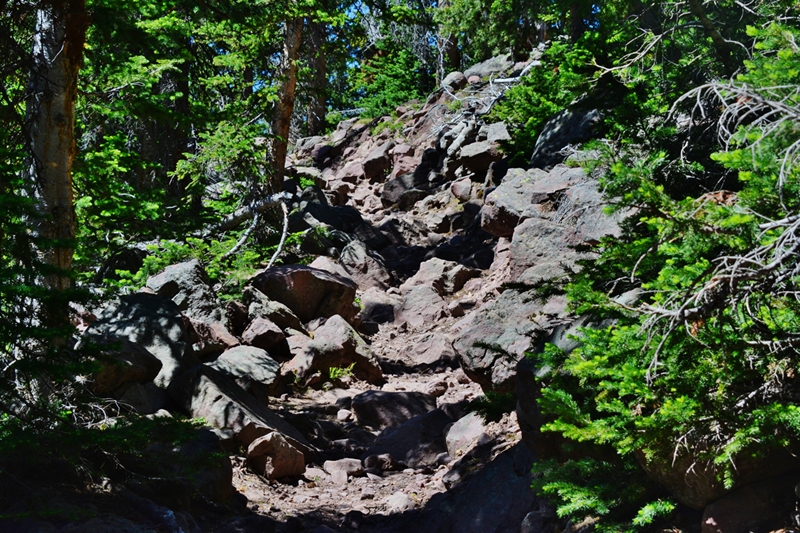
No, we're not lost in the Wilderness, but going UP THE TRAIL!
I actually did better with my lightweight trail runners than I would have with boots!

We won't starve either, as "the spinach of the weed world" is in full bloom, offering more vitamins & minerals overall than any vegetables you'll find in the supermarkets......oh, by the way they are DANDELIONS, brought early on to the New World because of their medicinal qualities......and has spread everywhere in the hemisphere--including in the patio of friends in Patzicia as seen below in my recent Supervisory trip to Guatemala.

I continue up the "Grandaddy Trail."


I continue up the "Grandaddy Trail."


One of the varieties of WILD DAISY'S

One of the many "textures of nature" that never cease to awe me along the trail.

When you get to this sign in a sandy area, you have left behind 8 switchbacks that have taken you up to a new level, and from here on it's a more gradual climb up to Hades Pass.
It would seem ridiculous to all you younger people out there, but about every 30 minutes, I rest for 10-15 minutes, now getting a bit further off the trail, removing my pack--making it obvious that I was at least alive enough to remove my pack....and likely still alive.....

.....but also usually for rest stops I put on my extremely lightweight wind breaker (3 oz.) that stuffs into a back pocket. The mosquitoes can't penetrate it, and it keeps my sweaty body from having chills which for older people can be dangerous.

You'll notice my OSPREY ATMOS 65 backpack which I introduced last year, and, in spite of weighing 4 lbs.--twice as much as recent packs used, but about the same as my original REI Morning Star pack in 2003. This one is the best thing I've every had on my back--hugging my back, distributing the weight evenly and is extremely stable. If it wasn't for the weight you eventually feel in your legs, you wouldn't even know it was there!

SPRING BEAUTY soon greets us along the trail........


........and all along the way we see WILD CANDY TUFT

Meet Tom & DeAnn COSTANZO......new High Uinta Friends, on a day hike to Grandaddy Lake. On their return they reported catching a few trout.
They wanted to know more about my 14 quite intensive years exploring & photographing the High Uintas Wilderness.....and so I got into....
..."the plan".....
to do a book with lots of the stunning color of the Uintas, yes, it would be a guide book for hikers and backpackers, but much more intertwining throughout it the incredible history, the fascinating legends and myths of gold & Big Foot, and, much more, with special emphasis on my personal survival experiences, and lessons learned that could save many lives and enhance everyone's enjoyment of the Uintas.
Their conclusions: "GET TO IT BEFORE IT'S TOO LATE!"

We have now climbed to a new elevation and begin seeing the always elegant
GLACIER LILLY


All of a sudden a family breezed right by me, also on a day hike to Grandaddy Lake.

We come to a small stream of good water that crosses the trail--the first and only water since crossing the bridge, where I usually replenish my supply of drinking water, and get my first shots of always beautiful MARSH MARIGOLD, above..........

..........and below its partner, WHITE GLOBE FLOWER.

I soon arrive at Hades Pass (around 10,650 ft.) and begin dropping down into the Grandaddy Basin.

"THE GRANDADDY OF THEM ALL"
glimpsed through the trees. Grandaddy Lake, the largest in the High Uintas, was named by pioneer artist/photographer, George Beard.

Another rest stop gave me the opportunity of meeting the family that had sped past me earlier.........

........so meet the BRIAN AVERY FAMILY. Sorry for not taking several shots to get one good one with everyone's eyes open!
Brian said he had seen my website and they seemed curious about what an old guy like me was doing in the Uintas......so with that opening I once again described my plan:
To do a book with lots of the stunning color of the Uintas none of which is seen in any of the guide books. Yes, it would be a guide book for hikers and backpackers, but much more mixing throughout the incredible history, the fascinating legends and myths of gold & Big Foot, and, I asked, "Do you know about the tie hackers?" They shook their heads, and I described these "unsung heroes of the Uinta's North Slope without whom the West might not have been won!" I went on mentioning Tom "Bear River" Smith, President Eisenhower's hero from Abelene, Kansas, and Beartown, where Tom got his nick-name, which tie hacker/railroad town was described as
"The liveliest if not the most wicked town in America!"
all tied to the Uintas, and much more that will be in the book, with special emphasis on my personal
survival experiences, and lessons learned that will save many lives
plus enhance everyone's enjoyment of the Uintas. They were wide eyed and seemingly pretty interested and said,
"WOW....You'd better get to it before it's too late!"
As I headed down towards Grandaddy Lake, many thoughts were bouncing around in my brain, and I concluded
that for a guy who even forgot his pants on this trip, maybe I'd better stop fooling around backpacking so much, and get to work on my plan,
BEFORE IT'S TOO LATE!

One reason I love to visit Grandadddy Lake in late June & early July, is that there are three small creeks on the west side of the lake, one we see above, which are invaded by thousands of native cutthroat trout for their annual spawn as you see in the following photographs.


I focus on this spot and get ready to snap off quick shots.....


I'm now working my way around the south end of Grandaddy Lake, with Hayden Peak, on the left, and Mt. Agassiz in the middle.
It was slow go detouring around many marshy, areas, or I guess I should say "boggy areas," as along the way I got a series of pictures of BOG LAUREL we see below, showing how it develops--rarely seen by most hikers.


Eventually I climbed up above the lake and found a meadow where I could set up my little camp in full view of East Grandaddy Mountain and the saddle, down from which I bivouacked one night a few years ago to get some unique photos of Grandaddy Lake.
I zoomed in on the approximate area ............


.............where I set up my bivouac camp.


But, on setting up my camp my first order of business was RECOVERY from at least 6 miles of hiking that day........all on top of possibly another "error" but this one not funny as prior to leaving all of a sudden I felt a small cough beginning.....but of course, me being "tougher than nails," I would be able to handle that with no problem.......

......but I needed to RECOVER from a hard 1st day of a new season, downing a recovery drink of ENDUROX, plus a Power Pak.......but the cough had got worse and so I took other supplements that normally worked well to fend off sickness, like Glutamine & Wellness Formula (which I didn't have enough of).

.......and nearby beautiful ALPINE BUTTERCUPS

Night came and I got out my book, a Father's Day gift from a dear friend.

But, my glasses had one lens popped out, and no matter what I did I not only couldn't get it back in, but the other one popped out too............it was hard to do things right without seeing clearly what I was doing........

............another in my "comedy of errors!" I finally got one in.....sort of, and read 4 pages of the Forward using one eye and sort of learned why my pirate ancestor Henry Morgan, with a patch over one eye, had such a nasty attitude!
Note: If you didn't know my entire name is Cordell MORGAN Andersen, Morgan being my mom's maiden name....and my possible connection to the Pirate and excuse for sometimes having a nasty attitude!

By 2:00 AM my cough & wheezing had got so bad that it started worrying me a lot, and I got out my Emergency Meds/Supplements, with: Top row, Ibuprofen, Walmart "Excedrin," Wellness formula, & the emergency Anti-biotic; Bottom, Sleep items, Magnesium, Digestive enzymes, more Sleep items, & Glutamine. To maybe be able to meet my objectives.....and at least get back to civilization, I started the anti-biotic--a 5 day treatment, but which builds up in the body with its curative effects lasting another 5 days.
I got through the night, and time for breakfast..........

..........which was Granola, plus raisens, dehyrated bananas, with eggnog--half on the granola, & half as a drink. You'll notice, no expensive shaker bottles--rather from peanut butter, jam, or whatever....with smooth interiors easy to clean, but all wide-mouthed to easily pour in powders, etc.

When the food was ready I got out my teeth......and added two more items to my list of
"comedy of errors."
The Adhesive I had brought was one that has been in my car, and for whatever reasons had got thick and hard and I had one heck of a time getting any out, so from the beginning I had trouble, but found an old tube that had just a little left that would work and last for maybe a day or so, but........
......."the comedy of errors" was to get even more interesting!

When I took out the upper that was anchored to my one last tooth.... the tooth (a crown) came out, but luckily didn't fall onto the ground and get lost, rather stuck in the denture as you see below--the white one right in the middle.

It was actually a crown with its post, as you see below, but I needed it to anchor the upper denture........in the meantime I couldn't eat anything that required chewing! So.........

........I went to work cleaning and drying, not seeing very well with only one eye--no perspective, and got into my Emergency Repair bag for my PLASTIC SURGERY cement and glued the crown back onto its deteriorated base.
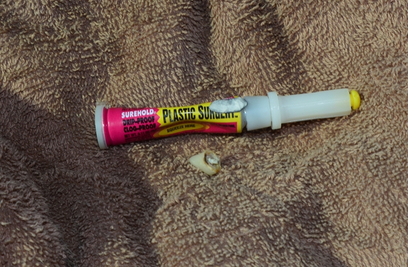
The repair only lasted for a day, and then had to be cemented in again.....but got me through the trip! This cement always goes with me, having repaired crowns several times, glasses, leaks in water bladders, air mattress, etc. It is far superior to Super Glue. Link to it on my GEAR/SUPPLEMENTS, page.
Note: At home, with glasses fixed at Walmarts, but told they would pop out again as they were worn out--so needed new ones--I solved that with two drops of Plastic Surgery on each so they'll never pop out again, but then, able to see, did a good job cementing my crown that continues to anchor my upper denture!
The thought occurs to some that to cement the crown onto a rotted base might not work too well--but, the Plastic Surgery glue is highly disinfectant and hopefully inhibits continued deterioration of the bas--for a while....sort of. So far it's working since returning home & doing a thorough and careful job of cementing it back on.
The thought occurs to some that to cement the crown onto a rotted base might not work too well--but, the Plastic Surgery glue is highly disinfectant and hopefully inhibits continued deterioration of the bas--for a while....sort of. So far it's working since returning home & doing a thorough and careful job of cementing it back on.
Mentioning SUPPLEMENTS & SUCH, you might as well see the way I organize what is taken during the day......to get me through each difficult day & trip.

The "Morning" sections have what I begin the day with. Then after breakfast when getting on the trail, take the "Energy" section. "Noon" is for mid-afternoon, and "Night" prior to going to bed. The large tablets above are HGH (human grown hormone) Activators taken before going to bed at night.

For details, and links to all, go to my website and click on: GEAR/SUPPLEMENTS, and scroll way down
& at the end learn about "free nutrition."

For details, and links to all, go to my website and click on: GEAR/SUPPLEMENTS, and scroll way down
& at the end learn about "free nutrition."
Some of them have proven in personal tests to make such an obvious difference I have said
"I'd stop eating almost everything before eliminating them from my diet!"

GETTING RID OF THE LAST VESTIGES OF MY "BREAD BELLY!"
It was working as by the 2nd day I had to make a new hole in my belt.
Twenty lbs. had been lost since January and I was working on 10 more to get down to my weight when 20 years old.

We are looking up at East Grandaddy Mountain. My hike that day would parallel its base as I bushwhacked down to Fern Lake.....all of which had a purpose. My hike down towards the east was in hopes of finding something very strange seen in the area 12 years ago when Ted Packard and me bushwhacked down to Fern.........

...........and all of a sudden, right out in the middle of nowhere....and miles from any trail, there was an outhouse! Why I never took a picture of it, who knows, (of course now I take a picture of everything!) but I wanted to find it, try and identify where it had come from and get some pictures.

From up at a high point before dropping down this is a panorama looking north. Cyclone Pass would be in the dead center, then to the left Four Lakes Basin, Rocky Sea Pass, Naturalist Basin, and Mt. Agassiz.

I shouldn't have done it, as bushwhacking for me at my age becomes very difficult, if not an impossible task, especially as I was still struggling with the cough that if anything was getting worse. I have finally learned my lesson:
NO MORE BUSHWHACKING!
NO MORE BUSHWHACKING!
I come way down, and given up on finding the outhouse, veering off a bit to the north where on a hill I all of a sudden found an old rusty shovel and its handle.


I scraped off the rust to see better the markings on the shovel, you see above. I decided to look around a little and see what else I could find.

Close-by I found a rotted away tent..........
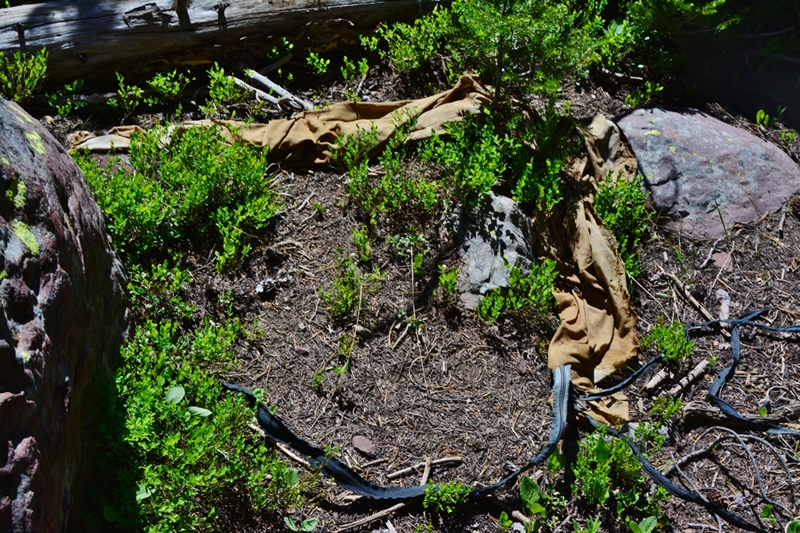
Then what looked like two tents that had been abandoned set-up, but, over who knows how many years, had deteriorated and come down with the polls sprawled over them.

I carefully lifted open the tents to see if there were any bones, or bodies, but could see nothing, although I certainly didn't tear things apart as I didn't want to disturb the scene in case authorities of whoever might be interested.

This is the same scene as the previous, but from the other end.

The red bag was empty.

There were some papers stuck together, but on carefully prying them open could see nothing distinguishable.

This is the only readable item I found at the site.

To pin-point the area, in case anybody is interested, from the shovel we see above, we are looking west at the cliffs that begin near East Grandaddy Mountain and continue on all the way to the trail down to Brinton Meadows. Between the picture and the cliffs, there is a stream that comes out of the base of East Grandaddy Mountain, tumbles down to the east, then turns north going between us and the cliffs. The same creek swings around the hill in question, and then parallels the Marla Lake Trail as it goes down east.

The shovel is in the extreme right of the picture, towards the bottom, the picture looking up at East Grandadddy Mountain. The site in question should be easy to find from the trail from Lodgepole Lake that rises, then begins to descend, going east paralleling the stream. The hill in question is there to the south of the trail as it turns east and begins its descent.

Of course for me, it was back to bushwhacking towards the east to find Fern Lake.

Along the way there were good views of the ground cover so frequent in the the Uintas, and for your interest I'll insert below a few pictures showing when it blossoms with a tiny flower, you might have never seen before.

ENJOY as we get closer and closer.


As has happened to me several times, I came upon Fern Lake from up high and scrambled down through the boulders to the lake, and had to take a cast or two for the healthy brook trout that inhabit its waters.

I haven't mentioned, but there were mosquitoes, a few at the Trailhead, but not in biting mode yet, and some all along the way.........


..........Fern being at a lower elevation--about that of the Trailhead, had quite a few, so I decided to head up the trail and camp on Grandaddy Lake.


A painting with these beautiful concentric lines & swirls would be a prize winner & sell for a hefty prize to decorate some wall to AWE all!

Up the trail, fairly close to Lodgepole Lake this cabin is found right along the trail. I will have to do a little research to learn about its history, but the one round nail I found, seen below, indicates it is from the 20th century.


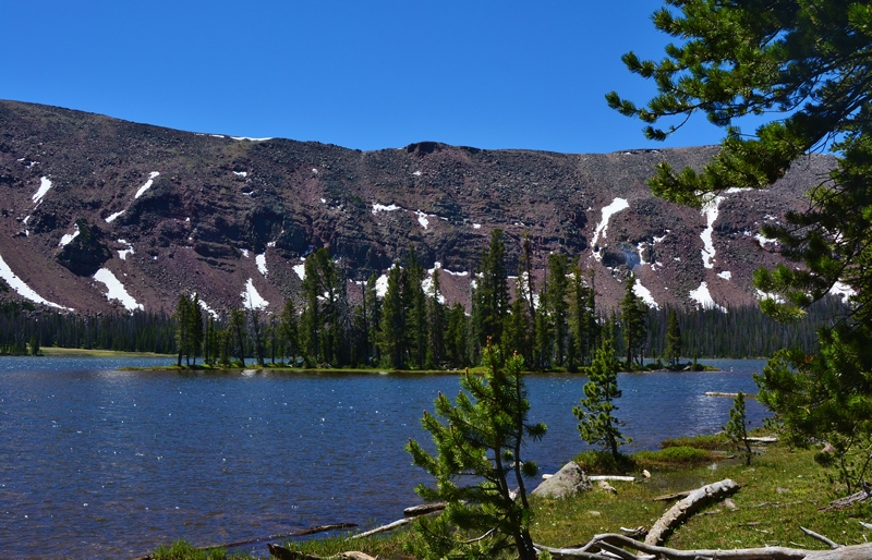
Then we come to Lodgepole Lake and this beautiful scene with Mt. Agassiz in the distance.
Louis Agassiz was a Swiss-American biologist & geologist, living from 1807-1873 who spent time in the Uintas, many lakes in the vicinity of Mt. Agassiz & Naturalist Basin given names of some of his students. Interesting quotes from him are:
"I cannot afford to waste my time making money!"
&
"The study of Nature is intercourse with the Highest Mind. You should never trifle with Nature."
At Lodgepole Lake there is a stream to cross, but as you can see there is a "bridge" made up of a conglomeration of unstable logs. There was a time when without hesitation I would just go across, but not anymore.

Balance is one of the weak points in some of us old guys, and for the first couple of days of backpacking, it's best to be careful until you sort of get your "mountain legs" warmed up and working.

I did what I have learned is crucial for a crossing or a ford--get a sturdy pole, like the one you see in the picture, and use it to steady yourself as you carefully go across........

......even with that, the tail end of the crossing got a bit dicey as one log began dipping and turning, but, with my old "football agility" not completely gone, I was able to make a leap to one log and then to the bank safely. It's funny how such simple little things become
REAL BIG FOR SOMEONE IN HIS 81st YEAR.....maybe with dementia coming on!

My desktop image on my computer is now this wonderful scene.
I've got to check out this old ruin between the trail and the falls that plunges down from Grandaddy Lake.

Once again, this ruin is from the 20th century, as before 1910 nails were all square.

Up we go to Grandaddy Lake!


Outlets to alpine lakes, like Grandaddy Lake, that the native cutthroat trout couldn't get up from the rivers below, had many such lakes with no fish until fingerlings were hauled in using milk cans on the backs of mules, and later, from about 1955 on, by airplane drops.

Thanks to the FISH & GAME....now the DWR: Division of Wildlife Resources, we are blessed with some of the best fishing in the world.....

........and of course THANKS TO THE CREATOR for the endless beauty of every kind imaginable in our wonderful Wilderness Areas.

I'm back at the "Grandaddy of them all," looking towards Hades Pass, and will camp close-by, but at least 200 feet from the water & trails, and see how I feel tomorrow.
The plan had been to hike from Lodgepole Lake down to Shadow Lake, near Brinton Meadows, then down to Lost Lake and take the faint trail to Powell Lake.....but the faint trail followed years ago from Lodgepole down, is one of those trails that are disappearing as the Forest Service is letting such areas become a more true Wilderness with no maintenance of such trails....meaning it would be "bushwhacking," which I have to pretty much avoid now.
Sorry for being such a wimp....but in my 81st year I have to be careful!

I set up my camp and relax after a very long, hard day that somehow I was able to survive. It's good to see INDIAN PAINT BRUSH blooming, and all over the place are the mushrooms.....


I discuss some "mushrooms" I in my YouTube video:
#6-2013 BIG FOOT in the Uinta's East Fork of Blacks Fork?
on 2nd thought it might be in the following video:
#8-2013 Open Your Eyes to THE VISIONS OF NATURE


By now HEARTLEAF ARNICA is beginning to add its splash of color to the landscape.
I get through the night, but the anti-biotic hasn't been able to fend off the cough that has got worse.....mainly due to the previous day being just too much...much of it due to the bushwhacking from Grandaddy all the way down to Fern--that I'll never do again!
Viewing Hades Pass over Grandaddy Lake.
Viewing Hades Pass over Grandaddy Lake.

My plan had been to get to places requiring more bushwhacking as explained above, which I didn't feel up to, so I packed up and headed for the Trailhead, measuring with great caution my pace so that I'd make it to Hades Pass.............
Another view of beautiful Grandaddy Lake, & the Mountain saddle where I've made 3 trips to get the most spectacular view of the Grandaddies.
Making it to Hades Pass I'd THEN BE HOME FREE!

Made it to the junction at the south end of Grandadddy Lake, and soon was carefully starting up to the Pass which gratefully was achieved in great shape, and soon downhill 3 miles to the Trailhead.

On the switchbacks I was passed by a father, daughter and dog-packer.

By the 6th switchback, counting from the top, or 3rd coming up, I was in
THE QUEEN'S COUNTRY
The Queen being the QUAKING ASPEN, now Utah's State Tree....
.... in my opinion a great choice.
.... in my opinion a great choice.


The 7th switchback was long and with the happy sound of the creek splashing down the canyon to my left, and Heart Leafed Arnica, along the trail.

The switchbacks ended at the Wilderness boundary, and soon the welcome sight of my car in the Trailhead parking lot filled me with a great feeling of gratitude. I had done betweeb 16-18 miles, at least 6 of it bushwhacking, in 3 days while being
sort of sick....and got WARMED UP!
sort of sick....and got WARMED UP!

But I also learned the lesson that I've got get to the task of putting all of this together.....
......IN A PACKAGE LIKE NEVER SEEN BEFORE!

The parking lot was almost empty now........

.......only with a father and son heading up the trail for high adventure in the HIGH UINTAS WILDERNESS.
****************
NOW THE PLAN OF ACTION
for the
HIGH UINTAS WILDERNESS PROJECT:
I refer to my chat with Tom & DeAnn Costanzo and Brian Avery & family on the trail....both ending with them saying:
"WOW....You'd better get to it before it's too late!"
In summary "it" is:
A book with lots of the stunning color of the Uintas none of which is seen in any of the guide books, including the most exotic and stunning locations, often not even given mention in the present books. Yes, it will be a guide & "how to do it" book for hikers and backpackers (applicable in any "wilderness"), but much more mixing throughout the incredible history, the fascinating legends and myths of gold--even Butch Cassidy's connection, and, of course, Big Foot--even one personal experience. Then I asked,
"Do you know about the tie hackers?"
They shook their heads, and of course I jumped on it, describing them as:
"Unsung heroes of the Uinta's North Slope
without whom the West might not have been won!"
I went on mentioning the tie hacker's connection to Tom "Bear River" Smith, President Eisenhower's hero from Abelene, Kansas,
and the Uinta's Bear River where Tom got his nick-name at Beartown, which tie hacker/railroad town was described as
"The liveliest if not the most wicked town in America!"
That history and much more will be in the book, with special emphasis on.....
.......SURVIVAL....
..... relating histories of those lost in the Uintas & why,
plus my personal survival experiences, and lessons learned that will save many lives in any wilderness area,
This book, 64 yeas in the making, will enhance everyone's safe enjoyment of this great swath of fascination & beauty we call The HIGH UINTAS.
********************************************
Thanks for sharing your adventure Cordell. You are 'tough as nails' and impress me to atrive to keep going. Years ago my wife and I, my brother and nephews used to do a lot of backpacking, but with certain circumstances, I am the only one left with the desire to go again. At age 52 I know there is more to see and do than ever before. You are an inspiration to all of us Uinta lovers! Carry on good Sir!
ReplyDeleteHave followed you for years. This is the closest I have been to physically crossing your trail. Missed you by a few hours. You came out and I went in just hours later with a group of scouts headed to Fish Hatchery Lake. Always hope to instill in them your Uinta attitude: beauty, adventure, and leave no trace. Showed them your picture of Grandaddy from the East Peak and several duplicated the feat on day 3 of our 5 day adventure. The rest of the group hiked to the spring at Pinto Lake. Thanks for all the magnificent photos and excellent commentary.
ReplyDeleteGreat writeup. Ten more pounds :-)
ReplyDeleteGet er done. Cordell
ReplyDelete